This function can be activated by right mouse clicking on a layer and selecting Map> ToolTip Layer.
With this function turned on, as the mouse hovers over an object from the selected layer on the map, it will identify that object. For example with the Address selected as the ToolTip Layer, by hovering over a parcel, the Street number will be identified by the ToolTip. It also appears on the status bar at the bottom right of the screen.
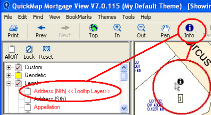
NOTE: If using the ToolTip for an object identified by a point or line, like address, the cursor needs to be within 5mm on the screen from that particular object. Therefore it will be important to be sufficiently zoomed out to locate the object. However, if the object is a polygon the cursor needs to be over it.