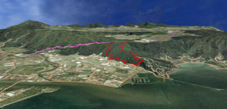
There is an option to view the map extent in 3D. To do this, zoom the map into the area you wish to view. The maximum Scale is 1:300000.
Click on the 3D Button on the Toolbar and it will open the 3D Options dialog box.
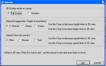 (This form can also be accessed from Tools-> Options->3D Options)
Select options required and click OK. It will take a short time to form the terrain. The example below has the AirPhotos layer turned on as well.
To fly around your Map, use:
|
|
Mouse |
To Turn |
|
To Move Out |
|
To Move In |
|
To Move Right |
|
To Move Left |
1 |
Decrease height when in 3D View |
2 |
Increase height when in 3D View |
3 |
Decrease Speed |
4 |
Increase Speed |
Esc |
Exit from 3D |
Click Mouse Button |
Will show grid (toggle key – click again to turn off) |
To copy 3D View into another Program (eg Word or Paint)
| • | Push Prt Sc key on your keyboard to copy the image to the clipboard |
| • | Press the ESC key to exit 3D |
| • | Open your destination program |
| • | CTRL/V to paste the image from the clipboard into your document |
.