Most property and Topographic data in QuickMap may be exported from QuickMap in a wide range of raster and vector file formats, and freely distributed in other software packages. Data may be exported in over 60 different Coordinate Systems for export. Data may be exported from QuickMap Enterprise at scales up to 1:250,000, or you can purchase the unlimited export option.
The Export tool is activated by selecting File> Export off the menu. From Version 6.3, the export form has a button Labelled "Other" which will allow you to choose from 60 new co-ordinate systems including NZTM and Local Circuits.. For versions prior to 6.3, the only supported co-ordinate system for exporting is NZMG.
The Enterprise product will Export all formats below, whilst Explorer will import all Raster Formats but only WKT under Vector formats.
| 1. | Select the Data format required. |
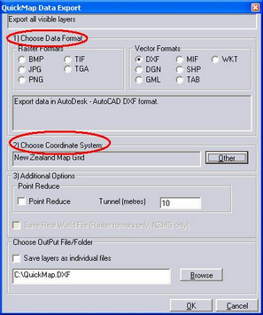
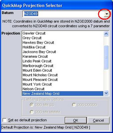
| 2. | Chose the Co-ordinate System - the "Other" Button will bring up co-ordinate options. The drop-down arrow next to Datum will enable selection of NZGD 2000, NZGD49 or WGS co-ordinates. |
For details on Point Reduce or Tunnel options.
All layers require you to be zoomed in to a scale of 1:250 000 or less (unless you have a bulk data license). Exporting will export all visible layers, not just the active layer. In addition it will export whole polygons, so if larger polygons are visible eg. the NZ layer, then the export extents will be very large. A tip is to turn all layers off using the ALL OFF button in the Layer Control Panel and then turn on all layers required to be exported.
For information about exporting larger areas, go to www.quickmap.co.nz
The data formats that can be exported from QuickMap are described under File Formats for Import or Export