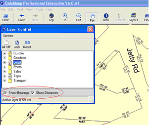
Bearings and Distances can be displayed by placing a tick in the boxes at the bottom of the Layer Control Window. These become active when at a scale of 1:5000 or lower.
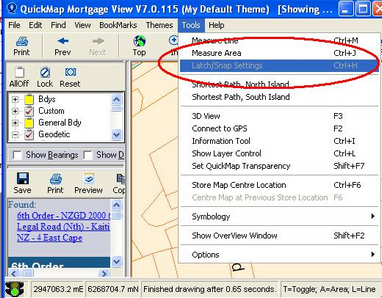
Distance Measuring Tool This is activated by selecting Tools>Measure from the main menu bar. Or by (Ctrl+M) for measuring Line or (Ctrl+J) for measuring Area, or by clicking the Add Button.
After activating the measure tool, you can measure distances or area by digitizing two or more points on the map. The distance and/or area is displayed on the message line at the bottom of the map. NOTE: The screen resolution should be more than 800 x 600 and the Window maximised to see the entire Message Line.
![]()
The following commands are available while measuring distance and/or Area
Esc |
The Escape key starts a new measurement. |
T |
Toggle between measuring Lines and/ measuring Area. (This shows on the Message Line at the bottom of the screen) |
L |
Measure Line |
A |
Measure Area |
Shift |
Holding the Shift key while dragging the mouse indicates Delta measurement (North/East) |
Ctrl + U |
Toggles between showing measurement areas in hectares or square metres (Also available under Tools-> Options->Show Areas in Hectares when Measuring) |
Ctrl+H |
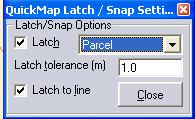
Display latch form. The latch form allows you to latch onto points in any layer for more accurate distance measurement. |
The latch form allows you to latch onto points in any layer for more accurate distance measurement. Make sure the Latch check-box is ticked, select the feature to be latched to
This option is only available when measure mode is on.