The layer properties form is used to set which scale range the layer is visible at by default, and what group the layer sits under in the layer control tool.
To access the layer’s properties, right mouse click on the required layer in the Layer control tool, and select Layer Properties off the menu. This will display the following form.
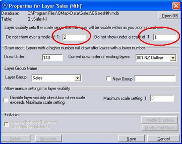
The top two text fields set the maximum and minimum scales that the layer is visible between. As you zoom in and out on the map, the layer visibility will automatically set depending on whether this scale range is within the current map scale.
By setting the maximum scale at 2 and the minimum scale at 1, the layer will never turn on automatically. A tick needs to be placed in the Layer check box for it to be visible on the map.
Note that the scale of the map is displayed in the bottom right hand corner of QuickMap.