QuickMap supports a wide range of file formats for import. Virtually all NZ projections are supported for import, including Local Circuit coordinate systems.
Import allows data to be loaded into QuickMap from file. The Import tool is activated by selecting File>Import off the menu. The Enterprise product will import all formats below, whilst Explorer will import WKT and WAY formats.
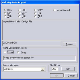
The data is loaded into the Edit Layer or a Layer created by the user. V6.3 onwards supports 60 different co-ordinate systems. Prior to that version the only supported coordinate system for importing data is NZMG.
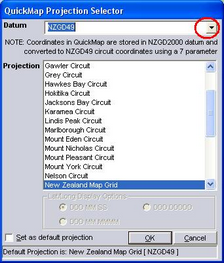
Select the "Other" Button to bring up co-ordinate options. The drop-down arrow next to Datum will enable selection of NZGD 2000, NZGD49 or WGS co-ordinates.
Select the layer to import into and set the GP for these features.
File formats are described in turn:
See also:
Convert a CSV File to MS Access
Import using Address Geocoding